Mosaicking ALOS data on the command line
Approach also has a script to generate mosaics of ALOS data, which has a fairly small tile size. Data from radar instruments is often very nosiy, so averaging data from multiple scenes can also be beneficial. Showing help ————
Help for mosaic.py can be viewed by typing python /path/to/approach/mosaic.py --help:
usage: mosaic.py [-h]
                [-te TARGET_EXTENT TARGET_EXTENT TARGET_EXTENT TARGET_EXTENT]
                [-tr TARGET_RESOLUTION] [-e EPSG] [-o PATH] [-v] [-y YEAR]
                N [N ...]

Generate a mosaic of scenes from ALOS-1 or ALOS-2 imagery.

Required arguments:
N                     Input files. Either specify a valid ALOS-1/2 input
                        file, or multiple files through wildcards.
-te TARGET_EXTENT TARGET_EXTENT TARGET_EXTENT TARGET_EXTENT, --target_extent TARGET_EXTENT TARGET_EXTENT TARGET_EXTENT TARGET_EXTENT
                        Specify image bounds as xmin ymin xmax ymax.
-tr TARGET_RESOLUTION, --target_resolution TARGET_RESOLUTION
                        Specify an image resolution for the output image
-e EPSG, --epsg EPSG  Specify the EPSG code of the output projection..

Optional arguments:
-o PATH, --output PATH
                        Optionally specify an output directory or file. If
                        nothing specified, we'll apply a standard filename and
                        output to the present working directory. Note: you
                        cannot process multiple input files with a single
                        output file name.
-v, --verbose         Like a chatty script? Use this flag.
-y YEAR, --year YEAR  Optionally specify a single year to process. If not
                        used, all years represented in infiles will be
                        processed.
An example run
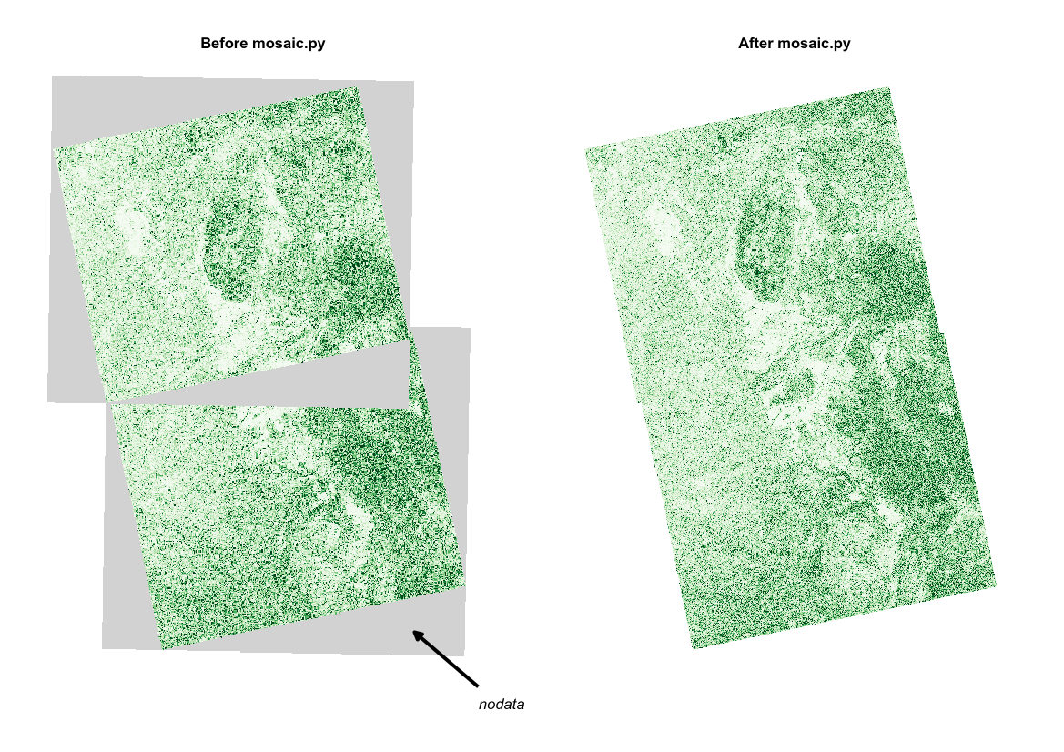
Let’s say we had processed two ALOS scenes, with filenames ALOS1_HV_20070702_ALPSRP076546990.tif and ALOS1_HV_20070702_ALPSRP076547000.tif, and that we wanted to combine these two adjacent scenes into a single image. An example command to submit would be (given a known output extent):
python /path/to/approach/mosaic.py -te 1100000 8900000 1210000 9050000 -tr 25 -e 32736 ALOS1_HV_20070702_ALPSRP076546990.tif ALOS1_HV_20070702_ALPSRP076547000.tif
If we wanted to specify an output directory that is different to the present working directory, and to print script progress, the command might be:
python /path/to/approach/mosaic.py -te 1100000 8900000 1210000 9050000 -tr 25 -e 32736 -o /path/to/output_directory/ -v ALOS1_HV_20070702_ALPSRP076546990.tif ALOS1_HV_20070702_ALPSRP076547000.tif
If we had multiple files to process, we can use wildcards to select all the files we want to pre-process as follows:
python /path/to/approach/mosaic.py -te 1100000 8900000 1210000 9050000 -tr 25 -e 32736 ALOS1*.tif
If we had multiple files to process, but only wanted to process those from a single year:
python /path/to/approach/mosaic.py -te 1100000 8900000 1210000 9050000 -tr 25 -e 32736 -y 2007 ALOS1*.tif
Note
Adjacent tracks of ALOS data are often poorly calibrated, the result of variability in the scene, particularly soil moisture. This package doesn’t fix this, but consider histogram matching as a potential solution.
Output
The script outputs two geotiff files. The first (g0_av*.tif) records the mean gamma0 backscatter from all input scenes. The second (nviews*.tif) records the number of scenes contributing to each pixel in the output image.